LA MILPA - TRAILS
Mahogany Trail
Mahogany Trail: The closest trail to the field station and the one that is most visited and toured by our guests. This trail not only goes through two of the most common habitat types in the area, but also clearly demonstrates the geology of the area which is limestone. This short trail begins with cohune forest and winds through mature upland broadleaf forest and ends in cohune forest again.
a.) Trail Design: A short looping trail that begins only 100 feet from the western edge of the field station.
b.) Degree of Difficulty: Moderate
c.) Slope: Gentle
d.) Length: 0.4 miles
e.) Objective: This trail is used to introduce our guests, particularly student groups, to semi-deciduous tropical forests. Well marked sings help identify many of the most common types of trees that occur in this upland broadleaf forest.
f.) Wildlife Occasionally Observed: Proximity to the edge of the station allow us to see animals such as white tailed deer. Spider monkeys, howler monkey, coatimundi and agouti can be observed. Birds: Ocellated Turkey, Great Curassow, Red Throated Ant-Tanager, Keel- billed Toucan and several species of woodcreepers.
g.) Other Attractions: This trail is where you can observe one of the biggest and oldest mahogany trees left in the area. The remains of what was a bigger mahogany can also be observed as its massive buttress roots are still standing. The exit to this trail is near the pond at the station where other birds can be observed and a five foot crocodile is resident.
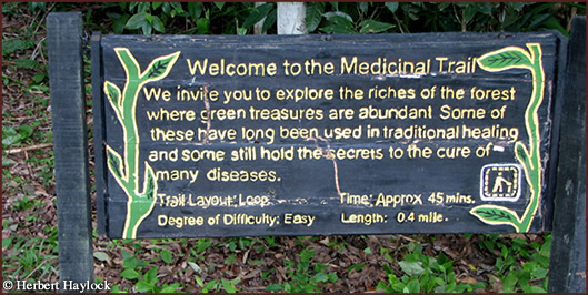
Medicinal Trail
Medicinal Trail: The medicinal trail begins just off the main road next to the station and exits on the main road about 200 yards from the station. The trail loops through successional and mature upland broadleaf forest. This change in the age of the forest gives us the opportunity to compare and observe plants in old and young forest.
a.) Trail Design: This trail is a loop beginning on the eastern side of the station or just on the other side of the main sign at the entrance to the station. Two thirds of the way into the trail it connects into the Lagunita Trail.
b.) Degree of Difficulty: Easy
c.) Length: 0.4 miles
d.) Objective: This trail is designed to educate our guests about the traditional medicinal uses of some of the most common plants in the area. Nature walks can also be done here.
e.) Wildlife Occasionally Observed: Gray Fox, Agouti, Tayra and Coatimundi.
Birds: Squirrel Cuckoo, Violacious Trogon, Black headed Saltator, Yellow-olive Flycatcher
f.) Other Attractions: The first half of the trail goes over a small grouping of Mayan mounds that have been mapped and studied by archaeologists stationed at Texas Camp.
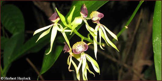
Orchid Trail
Orchid Trail: The shortest trail in the area but one of the most interesting as well. The trail circles a forest pond that is set in a swampy forest habitat called ‘The Bajo’. This short trail allows you to experience both flora and fauna of the bajo forests.
a.) Trail Design: A short circular trail set two miles off the road leading to the archaeological site. The trail winds around a pond that is inundated during the rainy season.
b.) Degree of Difficulty: Easy
c.) Length: 0.2 miles
d.) Objective: This trail offers the opportunity for viewing several of our native orchids that begin to flower during the dry season. At the beginning of the rainy season and particularly at night it is possible to see many species of frogs and in particular the very famous red-eyed tree frog.
e.) Wildlife Occasionally Observed: Because there is water here, we sometimes find Tapir tracks, agouti. Frogs such as red-eyed tree frog, yellow tree frog, sheep frog, and tungara frog. Birds: Green Heron, Bare-throated Tiger Heron, White-eyed Vireo, American Redstart.
f.) Other Attractions: This trail is next to an old gravel quarry that is semi-open. It is very likely that due to the openness of this area we are sometimes able to find a bird that is very common everywhere else except at La Milpa; the Common Paraque.
Bajo Trail
Bajo Trail: This trail flows through a transitional forest before entering the Bajo forest which is one of the habitat types most commonly found in the area. Because this has both transitional and bajo forest we are able to observe different plants that are particularly adapted to very wet and very dry soil conditions.
a.) Trail Design: A circular trail that can also be a loop if combined with the Well Trail. The trail entrance is three quarters of a mile north of the station and just off the main road. The first half of the trail is part of an old logging road and is thus wide and very spacious.
b.) Degree of Difficulty: Moderate
c.) Length: 0.7 miles
d.) Objective: For bird watching, particularly for avid birders looking for two Yucatan endemics; Gray- throated Chat and the Rose- throated Tanager. This trail also allows visitors the opportunity to observe a different forest type and to see many types of epiphytes in their natural habitat and at eye level.
e.) Wildlife Occasionally Observed: The rainy season leaves the forest floor wet and muddy allowing for Tapir and Jaguar tracks to be spotted with frequency. Other creatures observed include White-lipped Peccary, Coatimundi, Agouti, anole lizards. Birds: Gray-throated Chat, Rose-throated Tanager, White-bellied Wren, White Crowned Parrot, Brown Jay, Great Curassow, Blue Bunting, and Red-crowned Ant-Tanager.
f.) Other Attractions: The Bajo Trail is the only trail where we can find the Logwood Tree which was used by early British settlers as a dye for the textile industry. A large Chicle tree half way into the trail has scratch marks on its roots that are likely from one of the large cats, either puma or jaguar.
Lagunita Trail
Lagunita Trail: One of our longest trails that begins as secondary forest and ends in mature forest growth. Half of the trail at the beginning is the remains of an old logging road and is thus wider than the average trail which is advantageous when touring large groups. The width of the trail also increases chance for viewing wildlife and is highly recommended for this purpose.
a.) Trail Design: This trail is a long loop that begins where the Medicinal Trail ends on the main road about 200 yards from the station. The first hundred yards of the trail go through relatively new growth forest while the rest is old and mature broadleaf forest.
b.) Degree of Difficulty: Easy
c.) Length: 0.9 miles
d.) Objective: This trail because of its width is best recommended for bird watching and any nature walk. Mature forests are relatively open in the understory and this allows for easier spotting of birds and other animals and for this the Lagunita Trail is recommended.
e.) Wildlife Occasionally Observed: Spider Monkeys, White-tailed Deer, Agouti, and Kinkajou at night, Tayra, Coatimundi and Tamandua. Birds: Great Curassow, Crested Guan, Great Tinamou, Slaty – tailed Trogon, Spotted Wood Quail, Collared Aracari, Red-capped Manakin, Black-faced Antrush.
f.) Other Attractions: Half way through the trail it is possible to see several Mayan mounds of reasonable size that are of interest and work to the archaeologists who are here yearly. A large strangler fig is next to the trail just where the trail begins to narrow. This fig has now killed two trees it was growing on and on the fig sits a massive vine that can be confused for another fig.
Chicle Trail
Chicle Trail: The Chicle Trail loops through mature broadleaf forest. This trail is very hilly, especially near the entrance and although chicle trees can be found all over, here we can observe several large trees very near the edge of the trail.
a.) Trail Design: One of our longest trails, the chicle trail is a loop beginning 100 yards from the western edge of the station and is on the side of the road leading to the archaeological site. This trail exits on the main road and exactly on the opposite side that is the exit of the Lagunita Trail.
b.) Degree of Difficulty: Difficult
c.) Slope: Hilly
d.) Length: 0.7 miles
e.) Objective: This trail can be used as a hiking trail for anyone seeking a bit of a challenge in terms of the terrain. Trail used mainly with student groups and particularly in doing one of our activities called ‘Forest Observation’ where students are left alone for an hour in this forest.
f.) Wildlife Occasionally Observed: One of the few trails around the area where you can be guaranteed of seeing spider monkeys if you are there at the right time of the day. Coatimundi, Agouti, anole lizards, Howler Monkey. Birds: Crested Guan, Thrushlike Schiffornis, Golden-crowned Warbler, Pale- billed Woodpecker, Grey headed Tanager, Lesser Greenlet, and Chestnut-collared Woodpecker.
g.) Other Attractions: It is possible to see on the hilly sides of this trail where the ancient Maya quarried limestone for use on their buildings and other construction.
La Milpa Archaeological Site Trail
La Milpa Archaeological Site Trail: This is quite easily the most exciting and productive tour that any visitor can take while visiting La Milpa Field Station. This trail goes through under brushed upland broadleaf forest that is surrounded by the third largest Mayan site in Belize. The trail goes through mostly mature upland forest but also covers an area of cohune forest that is of secondary growth.
a.) Trail Design: The site of La Milpa is located three miles west of the station and is accessed by a gravel road that is also a dead end road. The trail begins at the end of this gravel road and includes a steep and sometimes slippery climb up a hill at the very beginning. There are four Mayan plazas through which the trail meanders, looping back out to the main plaza and finally back to the parking lot. The first or main plaza is massive and is the location where most important structures were built.
b.) Degree of Difficulty: Moderate
c.) Length: 0.5 miles
d.) Objective: La Milpa Site is an unexcavated archaeological site offering visitors the opportunity to learn and experience the wonders of this ancient civilization. The upland broadleaf forest surrounding the site is one of the most biodiverse and is thus highly recommended for wildlife spotting and especially for bird watching. Many of the most exciting and rarest sightings of birds and wildlife have come from this site and is thus considered the main tour for any visitor.
e.) Wildlife Occasionally Observed: Spider Monkey, Howler Monkey, Agouti, White-Tailed Deer, Tayra, White-Lipped Peccary, Anole Lizard, Silky Short- Tailed Bat, Red-Brocket Deer, Tamandua. Birds: White-breasted Wood-Wren, Royal Flycatcher, Rufous-Tailed Jacamar, Black-Cheeked Woodpecker, White- Whiskered Puffbird, Hooded Warbler, Eye-Ringed Flatbill, Sepia Capped Flycatcher.
f.) Rare Birds: Crested Eagle, Lovely Cotinga, Tody Motmot, Collared Trogon, Ornate-Hawk Eagle, Double-Toothed Kite, Scaly-Throated Leaftosser, Strong-Billed Woodcreeper.
g.) Other Attractions: La Milpa Site is part of an ongoing archaeological research project being undertaken by the University of Texas. Teams of archaeologists are scattered throughout the site during the work season which begins in May and ends in July. While on site, it is possible to see and learn about specific areas of the city being excavated. With special permission it is even possible to join these researchers for a day of work in order to experience true Mayan archaeology.
Well Trail
Well Trail: A trail that offers variety of habitats thus increasing chances for spotting wildlife and birds. The trail flows through upland broadleaf forest that is interrupted in two areas by secondary growth forest. If used in combination with the Bajo Trail which it intersects at the end, it then becomes the longest trail at the station.
a.) Trail Design: This trail offers the opportunity to do this one relatively short trail or continue on further and into the Bajo Trail. The first and shorter option begins north of the station, behind the dormitory and through the Texas Archaeology Camp. This then goes through relatively mature forest and a patch of young forest that was most likely a Milpa farm 25 years ago. Near the end of the trail there is a clearing that has an old Mayan well. The loop is completed with the trail connecting out to the main road. If the destination is the Bajo Trail one only needs to continue on the trail just north of the Mayan well.
b.) Degree of Difficulty: Moderate
c.) Length: 0.6 miles
d.) Objective: This trail is used for bird watching and as a general nature trail. The trail cuts right through a relatively young forest that is next to the mature or older forest. This allows for student groups to undertake research projects that seek to compare vegetation types in both areas.
e.) Wildlife Occasionally Observed: Spider Monkey, Agouti, Caligo Butterfly, White-Tailed Deer, Coatimundi, Howler Monkey. Birds: Great Curassow, Tawny-Crowned Greenlet, Magnolia Warbler, Great Tinamou, Black-Throated Shrike Tanager, Plain Xenops, Bicolored Hawk.
f.) Other Attractions: The well Trail is so named for having a Mayan well near the end of the trail. This is an old well that is easily several hundred years old. This fifteen foot well still holds water and was used as the original source of water for the station when it got started in the late 1980’s.
We request that for your safety you remain on the trails at all times. Please do not leave the trail system and wander off from your group or guide. It is easy to get lost or disoriented under the thick forested canopy. We have a trail map in your room directory that can lead you on your way to exploring the trail system with the help of your friendly resident guide. Also, a large trail map is located close to the Education Center and Dining Room Porch.
Most are in walking distance with difficulty levels from easy to difficult. Along these trails you will experience the majesty and complexity of the tropical rainforest. A naturalist guide will accompany you on your forest jaunts so that your experience is a fulfilling one. However, if you are experienced and comfortable on your own in the rainforest, you can explore the trails at your leisure. You must inform your naturalist guide or the Station Manager or any staff in their absence about where you are going so that we know your whereabouts at all times on the property.
Our tour guides are expert at identifying wildlife and plants and discussing environmental topics, the Maya civilization, and history of Belize among others. Also, you are invited to learn about and participate in the conservation work that Programme for Belize does in and around the RBCMA.
All overnight guests are invited to early morning bird and night walks. Guests staying multiple nights are also offered a night safari. Please make arrangement with your naturalist guide or station manager.
The La Milpa Archaeological Site, the 3rd largest Mayan site in Belize, has a trail system beginning three miles from base camp. Here you can explore an undeveloped Mayan site and step back in time to the days of priests, lords, and ball-players. The Dos Hombres trail, which leads to another undeveloped Mayan site, is approximately 10 miles away and the trail itself is about 2 miles. This is our most difficult trail.
At both these sites you can encounter howler and spider monkeys, numerous birds and other critters of interest.